A Unique Apache National Forest "Find"
FROM:  Myron & Nancy Calhoun, 2001 PIT (Passport In Time) Volunteers

TO:  Cynthia Benedict  Forest   Archaeologist  Cibola National Forest
     Cliff Nicholl     District Archaeologist  Magdalena Ranger District
     Linda Popelish    District Archaeologist  Mount Taylor Ranger District
     Rebecca Stoneman  District Archaeologist  Mountainair/Sandia R. District

CC:  Other PIT Volunteers: Denver Burns, Dan Caspary, Orville Daniels,
     Jean Fulton, George Leighton, Joanne Morgan, and Shana Stern
For the uninitiated, PIT (Passport In Time) is a program which coordinates
volunteers assisting the National Forest Service in some of its many duties
and functions. Nancy and I spent a very-enjoyable week
dry-camping in a part of the Cibola National Forest in central New Mexico
and doing "surveying and recording" -- that is, we volunteers spaced
ourselves 10-20 yards apart and tried to stay in a (ragged) line while
walking back and forth (think "grid") over an entire section (640 acres)
of National Forest, "surveying" (i.e., looking for) signs of
ancient-American occupation and then, when we found a more-than-usual
amount of "sign" in one area, "recording" what we found.
We were lucky with our vehicle (an old pick-up truck), but one of the
Forest-Service trucks had two flat tires in the 17 miles between the
nearest paved road and the campsite!
The whole experience was lots of fun, and we heartily recommend it!
Nancy and I wanted to visit some long-time family friends near Quemado, NM,
after our PIT
week, so that's where we headed after leaving the Cibola camping area
Friday afternoon. We found our 97-year-old friend (and owner of Mount
Trechado (a.k.a. Mount Techado) -- but that's another story) as hale and
hearty as anyone that old can be (but he died in 2005), but the others were out of town, so we
mostly just "bummed" around. (There are many "neat"
archaeological sites to visit near Quemado if you know where to look
and if you have permission to do your looking on private land!)
On Sunday, 6 May, 2001, we drove south from Quemado on highway 32 until
we were about a mile past the entering-the-Apache-National-Forrest sign.
After eating
lunch under a tree on the side of the highway, we climbed the fence and, just
to "kill" a few hours, started our own little survey. For about two hours
we found just enough potsherds to keep us interested, but then we found an
area with big potsherds that were so numerous (easily more than
any two sites we had seen in the Cibola NF) and so varied (don't
recall seeing any St. Johns Polychrome, however) that we decided we had
hit the mother lode!
The old room-block (perhaps 4-6 rooms with a small courtyard?) was easy to
identify, so we criss-crossed the area around it for another couple of
hours, just looking at the beautiful psycho-ceramics (cracked pots).
After having been embarrassed by Cliff's finding a broken axehead, I was,
perhaps, looking more carefully than ever before, so I saw what appeared
to be one end of a river-rounded rock barely sticking out of the
ground. When I picked it up and turned it over, it was a small mortar!
After noting its location, I ran to show it to Nancy, who was properly
impressed. But then she asked "Did you find the pestle?"
When I started scanning the ground near where I found the mortar, Nancy
said "Why not look in the same hole?", so I used the mortar to scoop
some more sand out of the hole and found.... well, just look at the
pictures:
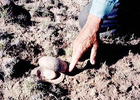
Picture 1 shows approximately how the pestle was nestled between the
mortars, but you'll have to imagine them totally closed and almost totally
buried.
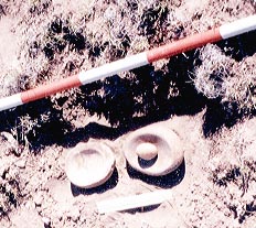
Picture 2 shows the pestle and mortars after opening; the
orange-and-white stick (six inches per color) is the walking stick Nancy
started using after leaving her blue one at the last site we recorded in
the Cibola PIT area. (If one of you is around when someone finds
that one someday, tell them to keep it with our compliments).
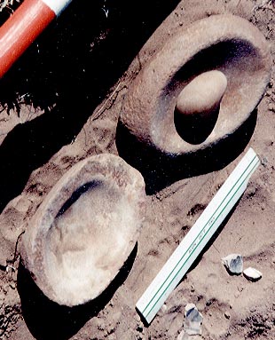
Picture 3 is a close-up; the white ruler is one of the PIT six-inch
rulers, and the potsherds are something Nancy wanted in the picture just
so I wouldn't be getting all the glory!
Apparently, several hundred years ago, an AmerIndian nestled the three stones
together and left them on the ground, thinking "I'm tired and there's always
tomorrow." But tomorrow never came! (Or perhaps he -- or she --
stored them in a little cloth or leather bag, dropped or otherwise lost the
bag, and the bag rotted and disappeared in the next 700+ years?)
Unfortunately, we needed to move on toward Canyon de Chelly, where we
were to act like tourists for a few days, so I re-buried the "find" a
little deeper than it was originally and noted its distance from every
rock, shrub, stump, tree, and fence post in the area!
Cynthia, Cliff, Linda, or Rebecca: we would appreciate it if one of you
could forward our little story and pictures to the appropriate Apache
National Forest person(s). Nancy and I would dearly love to return,
record the entire site, and "collect" our neat find for the appropriate
person(s) or agency before someone else digs it up and takes it home.
--Myron.
The REST of the story (kudos to Paul Harvey):
Shortly after emailing the above report, I received a phone call from John
Pierson, Apache National Forest Ranger, who asked me one question: "After
you ate lunch in that little grove of trees, did you cross the fence on
the east or on the west side of the road?"
After a short pause for me to remember which direction was which, I said
"On the west side", and he said (and I'm sure I could hear his voice gloat)
"Then you were on private land!"
One of our friends in the Quemado area is a rancher, and, in that almost-desert
where, in good years there may be enough grass to feed eight
cows per square mile (but, in recent droughty years, maybe four
cows if the elk don't eat it first!), ranchers have to own a lot of
square miles just to run a few cows. So, after my heart had pounded
a few seconds, I responded "Does that land belong, perhaps, to [and I
named our rancher friend]?"
I could almost hear Ranger John asking himself "How in this world does a
Kansas college professor know the name of the New Mexico rancher who owns
that in-holding in the National Forest?", and there was a really-long pause
before he answered "Yes". And then I replied "Good! Our families
have been friends for at least forty years; I'll call him to let him know we
were trespassing on his land and promise to take him out and show him our
'find' the next time we visit."
I did call our friend and apologized for trespassing, and then -- two years
later -- we returned to New Mexico to visit and show him "our" treasures.
He called it "a once in a lifetime find" we'll never be able to beat
and suggested we probably oughta take up another hobby!
Several years later I learned, from a publication from Harvard
University's Peabody Museum: "The William's Site: A Frontier Mogollon
Village in West Central New Mexico" by Watson Smith, that we were
probably on the western edge of that village. The site was excavated
because a new highway was going to run right through the middle of it.
Six boxes preserve our freedoms: cash, soap, ballot,
witness, jury, & cartridge
Barbershop Tenor and Life member of SPPBSQSUS
Amateur Radio Operator (WØPBV)
Life Member of both the NRA and GOA
This page was last modified on Tuesday, 24 March, 2026.